
ONLINE REPORTING FOR PRODUCERS
This site works best on desktop or laptop on Microsoft Edge and Mozilla Firefox. For login assistance, please contact the NRD at 402-443-4675.
Groundwater Management Area
Like most of Nebraska, the Lower Platte North NRD has an adequate supply of clean groundwater. However, drought, excessive water use, and chemical contamination can threaten this precious resource.
In 1997, in response to rising nitrate levels in district groundwater, the NRD designated a Groundwater Management Area (GWMA) covering the entire district. The GWMA monitors and regulates both groundwater quality and groundwater quantity.
The NRD’s philosophy is that prevention is less costly than correction, so the GWMA emphasizes proactive protection of groundwater, rather than a reactive, corrective approach. Educational efforts are given priority, although regulatory controls are implemented when needed.
Groundwater Quality
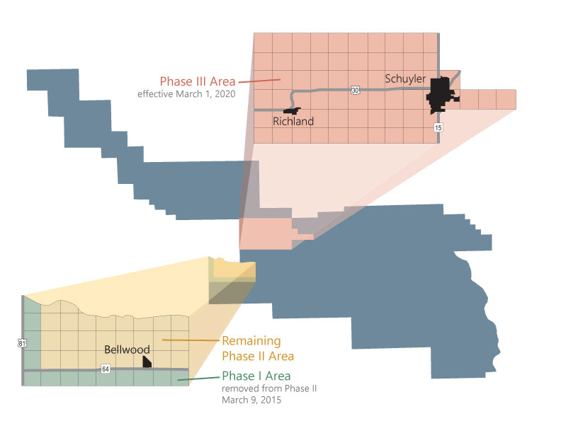
Since 1985, the Lower Platte North NRD has been monitoring nitrate levels across the district. In certain areas of the district, nitrate levels have already exceeded the health standard of 10 parts per million, and in other areas contamination seems to be on the rise. This was the major impetus for the creation of the Ground Water Management Area in 1997.
Currently, the majority of the Management Area is in Phase I, which emphasizes education about fertilizer use. There are two Phase II areas near Richland/Schuyler and Bellwood, and a Phase III are in the Richland/Schuyler area.
Groundwater Quantity:
AEM FLIGHT INFORMATION
Airborne Electromagnetic (AEM) surveys have played an essential role in the LPNNRD efforts to address water quality and quantity issues. AEM surveys provide geologic data through a rapid and efficient process. During flights, an electromagnetic field is continuously transmitted to the land surface where sensors under the aircraft detect the electromagnetic energy. Some sensors can even reach 1,000 feet below the land surface.
Flights were launched in 2009 and 2016 for the Platte/Colfax and Butler/Saunders “Special Quantity Subareas.” The 2016 flight results are now available on the Eastern Nebraska Water Resources Assessment (ENWRA) website.
In the summer of 2018, six NRDs conducted AEM flights with the help of Water Sustainability Funds grant dollars. Learn more about the 2018 AEM Flights on the ENWRA website.
Please contact the NRD office for more information on viewing files and data interpretation. More information can be found on the ENWRA website here.
VOLUNTARY INTEGRATED MANAGEMENT PLAN
The Integrated Management Plan was developed in consultation with its Stakeholder Advisory Committee and in accordance with the Nebraska Ground Water Management and Protection Act. The Act assigns the Department and the District the responsibilities and authority for management of groundwater, surface water, and their hydrologically connected areas in accordance with the Nebraska Groundwater Management and Protection Act, N.R.S. Chapter 46, Article 7.
In the Lower Platte North Natural Resources District, sustainable water resources are critically important. Water users include domestic, agriculture, industry, recreation, and wildlife; all such users rely on readily available water resources. The protection of this invaluable resource is paramount to preserving the standard of living, environmental health, and community vitality for District residents and future generations.
INTERPRETIVE GEOLOGIC CROSS SECTIONS
Interpretive geologic cross sections demonstrate the geology near the north and south borders of the Lower Platte North NRD. This provides a look at the sections as exposed vertical slices of the subsurface. The cross sections were drawn using information from the following sources: wells registered with the Nebraska Department of Natural Resources; test holes drilled by the Conservation and Survey Division, University of Nebraska; oil and gas bore holes reported to the Nebraska Oil and Gas Conservation Commission; and airborne electromagnetic surveys performed as part of the Eastern Nebraska Water Resources Assessment (ENWRA). The contacts between bedrock units are dashed because they were drawn using a small amount of data. The dashed water level line is also an estimate and is based on measurements taken by drillers soon after well installation.