
WATER DEVELOPMENT AREAS
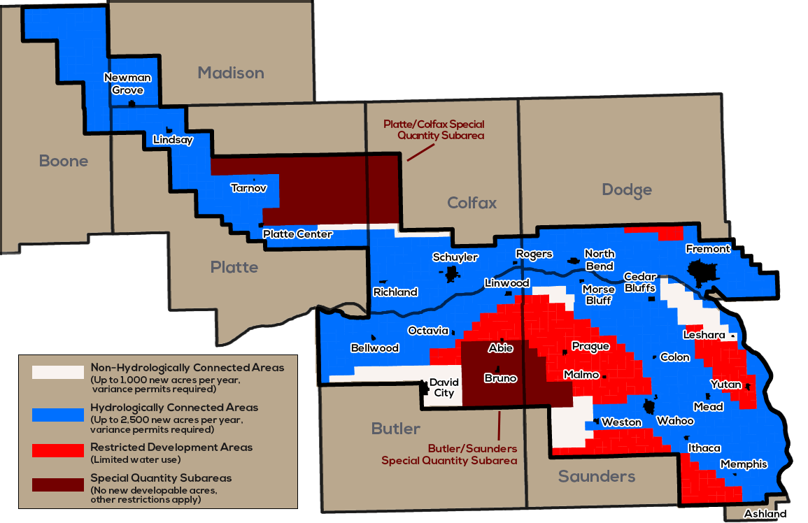
There are three major types of Water Development Areas in the Lower Platte North NRD:
• Non-Hydrologically Connected Areas (NHCAs) – up to 70 new acre feet per year
Deadline for variance request is August 15
• Hydrologically Connected Areas (HCAs) – up to 200 new acre feet per year
Deadline for Variance request is September 15
• Restricted Development Areas – no new irrigated acres or water use allowed
In addition, there are two Special Quantity Subareas in Butler/Saunders and Platte/Colfax counties. No new or expanded irrigated acres are allowed in these areas, and several other restrictions apply. Variances are required for any new irrigated acres within the NRD. Before a well permit can be issued, you must have a variance from the NRD.
The entire district is considered a “Level One” area, and all operators of irrigation, municipal, and industrial wells are required to be certified every four years.
Hydrologically Connected Areas
The NRD’s Hydrologically Connected Areas (HCAs) cover most of the Shell Creek, Platte Valley and Todd Valley aquifer regions. These areas were placed under a state-imposed moratorium in December 2008 when the Nebraska Department of Natural Resources preliminarily declared the Lower Platte Basin to be “fully-appropriated.” The state later reversed that preliminary declaration and the moratorium areas were opened back up to limited irrigation development.
Up to a total of 2,500 acres a year can be developed in HCAs. Variance requests must be received in our office by September 15th of each year to be considered for the following year’s irrigation season. These Variance requests will be reviewed, given a ranking score, and a limited number of applications may be approved at the following October Board Meeting. Please wait to hear from the NRD before you buy any equipment, drill a well, etc.
Non-Hydrologically Connected Areas
The NRD’s Hydrologically Connected Areas (HCAs) cover most of the Shell Creek, Platte Valley and Todd Valley aquifer regions. These areas were placed under a state-imposed moratorium in December 2008 when the Nebraska Department of Natural Resources preliminarily declared the Lower Platte Basin to be “fully-appropriated.” The state later reversed that preliminary declaration and the moratorium areas were opened back up to limited irrigation development.
Up to a total of 2,500 acres a year can be developed in HCAs. Variance requests must be received in our office by September 15th of each year to be considered for the following year’s irrigation season. These Variance requests will be reviewed, given a ranking score, and a limited number of applications may be approved at the following October Board Meeting. Please wait to hear from the NRD before you buy any equipment, drill a well, etc.
Restricted Development Areas
The NRD’s Restricted Development Areas encompass portions of the uplands region in Butler, Dodge and Saunders counties. Aquifers in these areas are thin or of limited size, therefore this type of development area is treated differently from the other two.
Offsets are required, so if a landowner wishes to expand their water use at one location, then a similar amount of water use or acres must be retired within the same subarea. In this case the offset will be treated as a water transfer.
Variance requests (with no offsets required) will be accepted for expanded irrigation if the field is within one mile of the border of the Restricted Development Area. Acre-inch allocations can be established and in a worst-case scenario, the well permit could be withdrawn and further water use prohibited.
If the Variance request is for a new well, then:
-
-
-
-
- New field limited to 160 acres or less
- No transfer of acres to another site
- Adjacent landowners will be notified
- Ground water levels could be measured by the LPNNRD
- Well owner must properly install a gravel pack measurement tube when well is drilled
-
-
-
If the Variance request is for a new well, then:
- New field limited to 160 acres or less
- No transfer of acres to another site
- Adjacent landowners will be notified
- Ground water levels could be measured by the LPNNRD
- Well owner must properly install a gravel pack measurement tube when well is drilled
APPLICATION DEADLINE
The deadline to submit applications can vary depending on the type of adjacent Development Area, but in most cases it would be best for the landowner to assume the deadline is August 15th so the application will be received on time at the NRD.
Variance requests from the RDA will be reviewed with other applications from the adjacent Areas, given a ranking score, and a limited number of applications may be approved at the following September or October Board Meeting for the following year’s irrigation season. Please wait to hear from the LPNNRD before you buy any equipment, drill a well, etc.
In the Restricted Development Area, Variances are also required on small capacity wells except for a domestic well irrigating less than 1 acre of land or a well used to water range livestock.
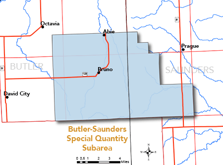
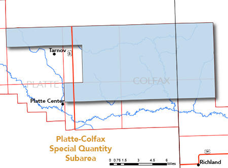
Special Quantity Subareas
There are two Special Quantity Subareas in the NRD, in Butler/Saunders and Platte/Colfax counties. The Butler/Saunders area covers approximately 56 square miles of east-central Butler County and 30 square miles of west-central Saunders County. The Platte/Colfax area covers approximately 100 square miles of central Platte County and 32 square miles of west-central Colfax County.
Groundwater Levels
With the help of area cooperators, a groundwater energy level monitoring network is used in the Lower Platte North NRD to track changes in groundwater levels.
Typically there are 140-150 wells in the NRD’s monitoring network. These wells are measured twice a year (once in the fall, once in the spring). The district also operates several dedicated monitoring wells that continually log groundwater levels.
The NRD uses 1987 as the “base year” for monitoring long-term trends in groundwater levels. (That year was chosen because it followed several years of above normal rainfall, which recharged aquifers to near ‘pre-development’ levels.)
The map shows overall conditions with the most recent water level readings factored in.
- Blue areas are “Level 1” areas, where water levels in the aquifer are within historical norms compared to the 1987 base year.
- Yellow areas are “Level 2” areas, where water levels in the aquifer have declined approximately 10% since 1987.
- Red areas are “Level 3” areas, where water levels in the aquifer have declined approximately 15% since 1987.
- Gray areas are areas where the NRD is still gathering data to establish a baseline.
In these areas, groundwater levels can be highly volatile and heavily influenced by drought and groundwater pumping.
Several requirements apply in the SQSs:
- acre inch allocation of irrigation water (the Butler/Saunders area was established in 2015 and the Platte/Colfax area was established in 2016) – the 2020 allocation is 27 acre inches over a 3 year period
- new or expanded irrigated acres with special variance and Board approval
- all certified irrigated acres need to stay current with minimal expansion allowed with NRD approval
- beginning in 2015, flow meters required on all irrigation wells (see requirements & approved models here)
- new domestic and livestock wells must be drilled to a depth that will avoid seasonal water declines caused by existing wells nearby
- Restrictions on pumping during certain times of the day or the establishment of a system of rotation for pumping could also apply in the SQSs.
VARIANCE REQUEST INFO FOR NEW IRRIGATED ACRES
Anyone wishing to develop new irrigated acres within the Lower Platte North NRD must apply for a variance from the district.
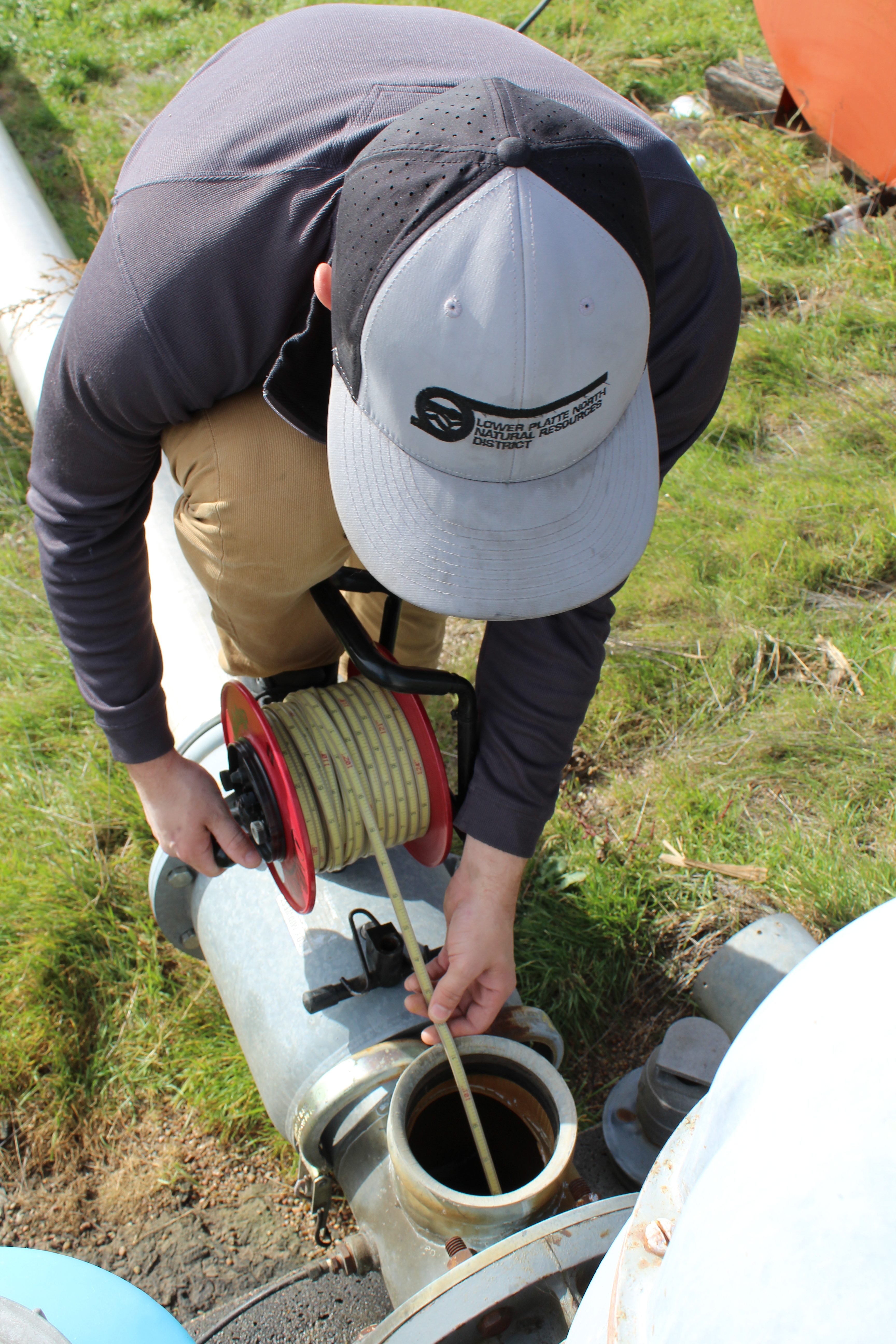
FLOW METER MAINTENANCE PROGRAM
Since 2008, the LPNNRD has implemented the requirement of installing a District approved flow meter on any new or replacement well. Thereafter in 2012, the District also required the installation of a flow meter on any expansion of acres from an existing well. This pumping information is invaluable to the District to know what has been pumped during years of extended drought. It is vital that the LPNNRD keeps track of this going forward into the future. In order to know the volume of water within our aquifer systems, we need to know the water that is being extracted.
An annual water usage report is required if you choose to participate in the flow meter maintenance program. Routine meter maintenance will ensure that the meter is reading accurately and prolong the lifespan of the meter. Accurate flow meter readings are not only essential for our records to know the volume of water pumped annually throughout the district but also essential to the producer to know what was more precisely applied to their crops. The flow meters will be maintained once every four years. The Lower Platte North NRD has a contract with Tri-City Meters Inc. for flow meter maintenance and repairs.
Irrigated Acre Certification
The Lower Platte North NRD began certifying irrigated acres in the district in spring 2010.
A common question received by LPNNRD is: “Why should I certify my acres?”
Certification is intended to catalog all existing irrigated acres and attempt to bring together records from LPNNRD, County Assessor and FSA. It is not uncommon for all three entities to have a different number of irrigated acres on a parcel.
The Nebraska Department of Natural Resources (NeDNR) conducts an annual evaluation of all river basins in the state to determine if they are “fully appropriated.” If a basin is declared fully-appropriated, NRDs are required to impose a stay on new water wells and expansions of water use, effectively halting the expansion of irrigation.
While the Lower Platte basin is not currently fully appropriated, that could change after any of NeDNR’s yearly reviews.
In the event that the Lower Platte Basin were to be declared fully appropriated, producers that have had their acres certified as irrigated by LPNNRD, prior to a declaration, would continue to have the ability to irrigate those acres. This is one way that certifying irrigated acres is advantageous to the producer.
In LPNNRD’s Restricted and Hydrologically Connected Areas, a variance is required to expand irrigated acres. Certified acres are used as the baseline when evaluating proposed changes in water use in the moratorium areas.
The intent is to make certification as simple and painless as possible for landowners. Landowners received a form to fill out regarding which well(s) were used to irrigate a parcel, the delivery mechanism for the irrigation, and whether the currently listed irrigated acres on file with the County Assessor was correct. Each packet included a detailed instruction sheet that thoroughly explained what was required for each question on the form.
To certify their irrigated acres, landowners filled out the Acre Certification form in its entirety and returned the signed and dated copy to the NRD.
Many landowners chose to call LPNNRD and set up a time to meet with staff to go over the paperwork. This came to be the preferred method as any questions or inconsistencies in the paperwork could be addressed immediately instead of having to try to get in contact with the landowner.
As a reminder, Acre Certification is an ongoing process. Acres that have already been certified need to continue to be irrigated two out of every ten years or they may lose their certified status. New irrigated acres, added through the variance or transfer process, will be sent the relevant certification forms once it has been determined the approved project was satisfactorily completed and the irrigation drawn on a map for reference.
Landowners need to be current on their NRD nitrogen management and water management certification training to have their acres certified, failure to maintain nitrogen certification will lead to a revocation of certified irrigated acres.
Failure to successfully certify irrigated acres with the LPNNRD can result in a cease and desist order against irrigation for the affected landowner.
LPNNRD encourages anyone looking to purchase a piece of property in the district that is listed as irrigated, to call the office and verify the certified acres prior to purchase of the ground.
Lower Platte River Drought Contingency Plan
Download a complete version of the current draft of the Lower Platte River Drought Contingency Plan here.
Tips for Conserving Water
To protect our precious groundwater supply, the Lower Platte North NRD encourages everyone to conserve water whenever they can. Conserving water isn’t just good for the environment — it’s a good way to save money too. Here are some guidelines you can follow that can help you greatly reduce water use.
Irrigation Efficiency
Irrigation is the largest water use in Nebraska. Take these steps to improve efficiency:
Crop Varieties
- Use more drought-resistant crop varieties.
- Recent research has shown that even regular corn varieties can be water-stressed when the corn plant is in its early growing stages and it will not affect yields if the corn receives adequate water in the tasseling to late reproductive phase. This can save two to four inches of water over the course of a summer
- A simple crop rotation of corn and soybeans can save water compared to continuous corn.
Flow metering
Using an ultrasonic flow meter, the NRD can quickly and easily check your irrigation system’s efficiency
Updating Equipment
Switch from gravity to pivot irrigation, or from high-pressure to low-pressure systems.
Tracking Water Use
Installing a water meter or time totalizer can help you track your water use. This will help you be more precise in your water applications (saving on fuel costs and using water efficiently), and can also help identify leaks or other problems with your system.
Water Your Lawn/Garden Efficiently
Outdoor watering can account for a large percentage of your overall water use. To help reduce this, use efficient watering practices:
- Use more drought-resistant grass varieties, such as fescue, zoysia, or buffalo grass.
- During the summer, let your lawn go dormant and water just enough to keep the roots alive.
- Avoid watering during the warmest times of the day.
- Avoid watering on windy days.
- Water in several short sessions rather than one long one to maximize absorption.
- Mulch your garden and flower beds to reduce evaporation.
Fix Leaks
The most common source of leaks is the toilet. To check your toilet for leaks, put a few drops of food dye in the tank and wait 15 minutes. If color appears in the bowl, you have a leak that should be repaired. Leaky toilets can usually be repaired inexpensively by replacing the flapper or adjusting the water level.
Dripping faucets can usually be repaired by replacing the rubber washer or O-ring inside the valve.
Wash Full Loads
When using a clothes or dish washer, wait until you have a full load to avoid wasting water. Clothes washers can use as much as 30-35 gallons of water per cycle. A full dishwasher is more water efficient than washing the same load by hand.text
Don't Waste Water
A few common-sense measures can help you reduce water used for everyday activities:
- Turn off the water when brushing your teeth or shaving. This small step can save more than 5 gallons a day.
- Don’t let the hose run when washing your car. Use a bucket of water and sponge, then turn on the hose only to rinse.
- Don’t run water from the faucet to get cold water. Keep a bottle of water in the refrigerator.
- Use brooms instead of a hose to clean patios, decks, sidewalks and driveways.
- Use a rinse basin or sprayer for rinsing hand-washed dishes and other items instead of running water.
- Reduce flushes by not using the toilet as a waste paper basket.
Reuse Water
Don’t waste your “gray” water – put it to use:
- Water plants with leftover water from washing vegetables, leftover coffee, etc.
- Wash patio furniture, cars, plant containers, waste baskets and other items near or on the lawn to reuse the water. Use an environmentally safe mild cleaner — avoid strong cleaners that may damage plants.
Install Water-Saving Equipment
By installing water-efficient equipment and/or replacing old fixtures and appliances, you can achieve significant water savings.
Additional Tips
Toilets and showerheads installed prior to 1994 should be updated. Install an aerator to your faucets to achieve a similar stream using less water.
Consider replacing an old traditional water softener with an “on-demand” model. On-demand softeners use less water by responding to actual water use and water hardness rather than a timed schedule.